NASA-ISRO NISAR Satellite: Revolutionizing Earth Observation in 2025
The NASA-ISRO Synthetic Aperture Radar (NISAR) satellite marks a monumental milestone in global space exploration, uniting the Indian Space Research Organisation (ISRO) and the US National Aeronautics and Space Administration (NASA) in their first-ever joint Earth observation mission. Set to launch on July 30, 2025, from the Satish Dhawan Space Centre in Andhra Pradesh, India, this cutting-edge satellite promises to deliver high-resolution data that will transform how scientists, policymakers, and disaster management teams address critical global challenges like climate change, natural disasters, and agricultural planning. Powered by ISRO’s GSLV-F16 rocket, this mission is not just a technological triumph but a symbol of international collaboration, showcasing what two democracies can achieve when united by a commitment to scientific innovation and global welfare.
A Decade in the Making: The NISAR Journey
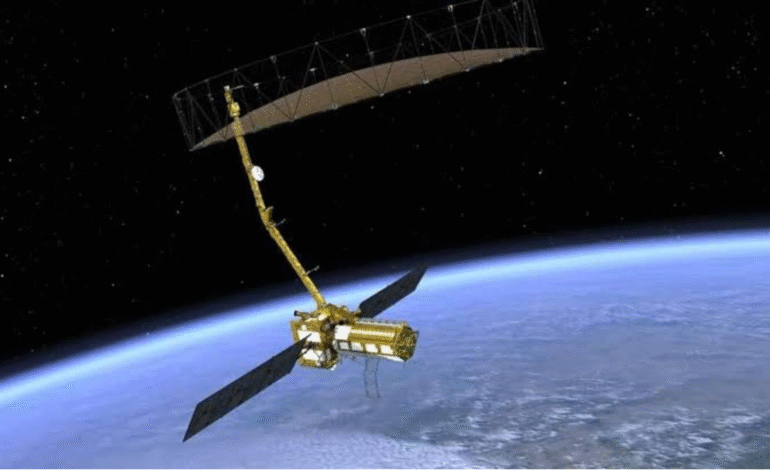
The NISAR project, a $1.5 billion endeavor, has been in development for over a decade, reflecting the dedication of both NASA and ISRO to push the boundaries of Earth observation technology. This satellite is designed to orbit Earth 14 times a day, completing two full scans of nearly the entire planet every 12 days. By capturing high-resolution images of Earth’s land and ice surfaces, NISAR will provide unprecedented insights into dynamic environmental changes, from shifting glaciers and ice sheets to areas vulnerable to landslides, earthquakes, and volcanic activity.
What sets NISAR apart is its dual-band radar system, a first for both NASA and ISRO. Equipped with an L-band radar (25cm wavelength) and an S-band radar (10cm wavelength), the satellite can capture intricate details about surface roughness, moisture content, and motion. This advanced technology enables NISAR to monitor a wide range of phenomena, including deforestation, urban expansion, agricultural productivity, and disaster preparedness, making it a vital tool for sustainable development and climate resilience across the globe.
A Historic Launch Powered by ISRO’s GSLV-F16
The launch of NISAR on July 30, 2025, at 5:40 PM IST (4:10 PM GST) is a historic moment for ISRO, as it marks the first time the Geosynchronous Satellite Launch Vehicle (GSLV-F16) will be used to deploy a satellite of this scale. This achievement underscores ISRO’s growing expertise in space exploration and its ability to execute complex missions with precision. The Satish Dhawan Space Centre, located in Sriharikota, Andhra Pradesh, will serve as the launchpad for this ambitious project, drawing global attention to India’s advancements in space technology.
For the UAE and the Middle East, where environmental monitoring and disaster management are critical due to the region’s unique geographical challenges, NISAR’s data will be particularly valuable. The satellite’s ability to track desertification, water resource management, and coastal erosion will empower regional governments and organizations to make informed decisions for sustainable development and climate adaptation.
Why NISAR Matters: Applications for a Changing World
NISAR’s dual-band radar technology is a game-changer for Earth observation. Unlike traditional optical satellites, which rely on visible light and can be hindered by clouds or darkness, NISAR’s radar can penetrate cloud cover and operate in all weather conditions, day or night. This capability ensures consistent and reliable data collection, making it an invaluable asset for monitoring natural disasters like floods, earthquakes, and tsunamis.
In the Middle East, where rapid urbanization and climate change pose significant challenges, NISAR’s data will support infrastructure planning and disaster preparedness. For instance, the satellite can detect subtle ground movements that signal potential landslides or earthquakes, providing early warnings that could save lives. Additionally, its ability to monitor soil moisture and crop health will aid agricultural planning, helping farmers optimize water use and improve yields in arid regions like the UAE.
Globally, NISAR will contribute to climate change research by tracking changes in glaciers, ice sheets, and sea levels. This data is crucial for understanding the impacts of global warming and developing strategies to mitigate its effects. From deforestation monitoring in the Amazon to ice loss tracking in Antarctica, NISAR’s comprehensive coverage will provide a wealth of information for scientists and policymakers worldwide.
A Symbol of Global Collaboration
The NISAR mission is more than a technological feat; it’s a testament to the power of international cooperation. As NASA Earth’s official X account stated, “NISAR is the first time NASA and ISRO have built Earth science hardware together. This powerful satellite will track changes on land and ice, from areas at risk for landslides and earthquakes to shifting glaciers and ice sheets.” This collaboration highlights the shared commitment of the US and India to advance scientific discovery and address global challenges.
India’s Minister for Science and Technology, Dr. Jitendra Singh, described the mission as “India’s scientific handshake with the world.” He emphasized that NISAR’s data will benefit not only India and the US but also countries across the globe, particularly in regions vulnerable to natural disasters and climate change. “This mission is not just about a satellite launch—it is a moment that symbolizes what two democracies committed to science and global welfare can achieve together,” Dr. Singh said.
For the UAE and the broader Middle East, this mission aligns with regional goals of fostering innovation and sustainability. The UAE’s own space ambitions, exemplified by the Hope Mars Mission and the Mohammed Bin Rashid Space Centre, reflect a growing emphasis on space technology as a driver of economic and environmental progress. NISAR’s data will complement these efforts, providing actionable insights for urban planning, water management, and disaster resilience in the region.
Technical Marvel: How NISAR Works
At the heart of NISAR’s capabilities is its dual-band radar system, which combines NASA’s L-band radar and ISRO’s S-band radar. The L-band radar, with its longer wavelength, is ideal for penetrating dense vegetation and monitoring changes in forests, wetlands, and soil moisture. The S-band radar, with its shorter wavelength, excels at capturing fine details about urban areas, ice surfaces, and geological features. Together, these systems provide a comprehensive view of Earth’s surface, enabling scientists to study everything from tectonic plate movements to crop health.
The satellite’s orbit is designed to maximize coverage, completing a full scan of Earth’s land and ice surfaces every 12 days. This frequent revisit time ensures that NISAR can capture dynamic changes in near real-time, making it an essential tool for disaster response and environmental monitoring. For example, in the event of a tsunami or earthquake, NISAR’s data can help first responders assess damage and plan relief efforts.
NISAR’s Impact on the UAE and Middle East
The Middle East faces unique environmental challenges, from desertification and water scarcity to coastal flooding and urban expansion. NISAR’s high-resolution data will provide critical insights for addressing these issues. For instance, the satellite can monitor groundwater levels and soil moisture, helping policymakers in the UAE and neighboring countries optimize water resource management in arid climates. Similarly, its ability to track coastal erosion and sea level rise will support efforts to protect coastal cities like Dubai and Abu Dhabi.
In addition, NISAR’s data will enhance disaster preparedness in the region. By detecting subtle ground movements, the satellite can identify areas at risk of landslides or earthquakes, enabling governments to implement preventive measures. This is particularly important for countries like Oman and Iran, which are prone to seismic activity.
The mission also aligns with the UAE’s vision of becoming a global hub for innovation and technology. By leveraging NISAR’s data, the UAE can strengthen its position as a leader in smart city development and sustainable urban planning. For example, the satellite’s ability to monitor infrastructure stability can inform the construction of resilient buildings and roads, ensuring long-term safety and sustainability.
How to Watch the NISAR Launch
Space enthusiasts in the UAE and around the world can witness this historic launch live on NASA+, NASA’s streaming service, at 4:10 PM GST on July 30, 2025. The broadcast will offer a front-row seat to the launch of the GSLV-F16 rocket from the Satish Dhawan Space Centre, showcasing the culmination of years of collaboration between NASA and ISRO.
For those in the Middle East, the launch is an opportunity to celebrate the region’s growing role in space exploration. As the UAE continues to invest in its space program, missions like NISAR highlight the importance of international partnerships in advancing scientific discovery and addressing global challenges.
The Future of Earth Observation
The launch of NISAR is just the beginning. As the satellite begins its mission, it will generate a wealth of data that will shape our understanding of Earth’s changing environment. From climate change mitigation to disaster preparedness, NISAR’s applications are vast and far-reaching. For the UAE and the Middle East, this mission offers a unique opportunity to harness space technology for sustainable development and regional resilience.
As Dr. Jitendra Singh aptly stated, NISAR is a “scientific handshake” that transcends borders, uniting nations in the pursuit of knowledge and progress. By combining NASA’s expertise in radar technology with ISRO’s prowess in space exploration, this mission sets a new standard for what collaborative science can achieve.