NISAR Satellite Launch Begins Historic 90-Day Space Preparation Phase
As the world awaits the landmark launch of the NISAR satellite on July 30, 2025, from India’s Satish Dhawan Space Centre, one intriguing fact is drawing attention: the satellite won’t begin scientific operations right after reaching orbit. Instead, the mission will enter a 90-day period dedicated to testing, calibration, and system checks before starting its ambitious Earth observation tasks. This time is not a delay but a critical part of the mission’s design, ensuring that the instruments are precisely tuned to deliver high-quality, reliable data for years to come. Jointly developed by NASA and ISRO, NISAR represents a fusion of advanced radar technology and international collaboration aimed at reshaping how scientists monitor the Earth.
The Power Behind NISAR: What Makes It So Special
NISAR, short for NASA-ISRO Synthetic Aperture Radar, is one of the most expensive and complex Earth observation satellites ever built. Developed over nearly a decade, the mission carries a staggering price tag of $1.5 billion. This price reflects the sophistication of the spacecraft, which is equipped with dual-frequency radar instruments—L-band radar developed by NASA and S-band radar provided by ISRO. These instruments allow NISAR to capture Earth’s surface in remarkable detail, regardless of cloud cover or lighting conditions. The satellite can detect changes on Earth’s surface as small as millimeters, making it invaluable for studying natural disasters, agriculture, glaciers, sea level changes, and tectonic shifts.
The spacecraft itself weighs over 2,300 kilograms and is mounted with a 12-meter-wide mesh reflector supported by a 9-meter deployable boom. This massive radar antenna, provided by NASA’s Jet Propulsion Laboratory, will allow the satellite to cover a swath of up to 240 kilometers with high-resolution imaging.
The Journey Begins: From Liftoff to Deployment
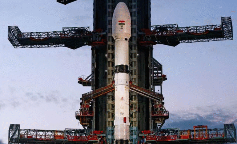
The launch itself will be historic. The satellite will be carried into orbit by the GSLV-F16, a powerful Indian rocket capable of delivering payloads into Sun-synchronous orbit. Liftoff is scheduled for the morning of July 30, and within about 18 minutes of flight, the satellite will separate from the rocket and begin its journey in space.
However, NISAR will not immediately begin its primary scientific functions. The initial days after launch are dedicated to orbital adjustments and the health check of the spacecraft’s basic systems. It will take approximately 10 days before the satellite begins deploying its radar boom and reflector antenna. This process, known as the deployment phase, is extremely delicate and is expected to take around 8 days to complete. By Day 18 post-launch, the spacecraft should be fully physically configured for its scientific mission, but the real work is just getting started.
Inside the 90-Day Commissioning Phase
After physical deployment, NISAR will undergo a comprehensive commissioning phase lasting about 90 days. This period is commonly referred to as the In-Orbit Checkout (IOC) phase and is standard for sophisticated satellite missions. The purpose of this phase is to methodically test and calibrate every instrument, subsystem, and operation of the spacecraft to ensure it performs exactly as expected.
The first several weeks are focused on confirming the satellite’s overall health. Engineers at both ISRO and NASA will closely monitor power systems, thermal controls, communication links, and propulsion components. This ensures that the spacecraft is stable, safe, and functioning reliably in its new environment.
Following these system checks, the mission team will proceed to gradually activate and test the radar instruments. Each radar will be switched on individually, and their raw data outputs will be carefully analyzed. These early radar images are used primarily for technical validation and are not intended for scientific use. They help engineers fine-tune the sensors, align the antenna precisely, and measure the accuracy of the data collected.
As the satellite orbits the Earth roughly every 98 minutes, it will begin collecting increasing amounts of test data. This data will be compared with known ground truth measurements to confirm its accuracy. The radar beams must be aligned with extreme precision to ensure consistent imaging across the globe. These tests are crucial because even a slight miscalibration could lead to flawed measurements, rendering the data useless for long-term environmental monitoring.
Early Imaging and Partial Science by Day 65
While the full commissioning period extends to 90 days, the mission team expects preliminary science data to begin flowing by Day 65. During this time, the radar systems will transition from engineering test mode to early operational mode. Although not yet considered fully validated, this early data can be extremely useful for certain applications and can provide scientists a glimpse into the satellite’s capabilities.
However, it’s important to note that this data is still under calibration and should not be used for mission-critical decisions or scientific publications until the full validation is complete. By around Day 70, both the L-band and S-band instruments should be operating in coordinated mode, capturing wide swaths of the Earth’s surface and offering a unique dual-frequency view of environmental dynamics.
Entering Full Science Mode After Day 90
The moment most scientists and stakeholders are waiting for arrives after the 90-day period. At this point, the mission officially enters its science operations phase. The instruments are expected to be fully calibrated, and the mission will begin consistent data collection aimed at a wide range of environmental studies.
NASA’s L-band radar is scheduled to operate for at least three years, while ISRO’s S-band radar is planned for five years of operations. If the satellite remains in good health and enough fuel is available for orbital maintenance, these durations may be extended.
During the science phase, NISAR will revisit the same locations on Earth every 12 days, enabling it to track slow changes over time. This is especially important for detecting movements in glaciers, monitoring landslides, measuring subsidence in urban areas, and observing agricultural land use.
The satellite will also support real-time event monitoring in the case of earthquakes, volcanic eruptions, and flooding. In emergency scenarios, data from NISAR can be prioritized and made available to aid response efforts, particularly in regions vulnerable to climate change and natural hazards.
Unique Radar Capabilities and the SweepSAR Technique
One of NISAR’s key innovations lies in its radar technology. Unlike conventional radar systems that scan in a narrow beam, NISAR uses a technique called SweepSAR. This method involves using multiple receiver elements to capture radar echoes across a wide swath, enabling high-resolution imaging over large areas.
The L-band radar, developed by NASA, operates at longer wavelengths and is capable of penetrating vegetation, snow, and even shallow ground layers. It’s especially useful for mapping forest biomass, detecting ice sheet changes, and observing tectonic shifts over long periods.
The S-band radar, developed by ISRO, operates at shorter wavelengths and is better suited for monitoring soil moisture, shallow flooding, coastal erosion, and certain types of vegetation cover. Together, the two radars provide a comprehensive view of Earth’s surface processes, with each frequency offering distinct strengths.
Why This Matters to the UAE and the Middle East
The launch of NISAR has implications far beyond India and the United States. For countries in the Middle East, including the UAE, the satellite’s data will play a critical role in understanding regional climate patterns, water resources, and land changes.
In arid regions where groundwater is a precious resource, NISAR can detect subtle shifts in the Earth’s surface caused by over-extraction of aquifers. This kind of information is invaluable for policy-making and water management strategies. Similarly, NISAR will assist in tracking desertification, monitoring vegetation in oasis ecosystems, and observing coastal dynamics along the Gulf coastlines.
Governments, universities, and private firms in the UAE can access this data for infrastructure planning, urban resilience strategies, and disaster preparedness. Since most of NISAR’s data will be publicly available within one to two days of capture, local users will not face barriers in accessing information. In cases of emergency or national interest, data can even be expedited.
The satellite also opens the door for scientific collaborations between the Middle East and mission agencies. Institutions in the Gulf may choose to develop algorithms, tools, and platforms that utilize NISAR’s data, leading to new research partnerships and innovation opportunities.
The Value of Patience: Why Waiting 90 Days Is Worth It
While the wait may seem long, the 90-day commissioning period is a vital step that ensures the mission’s success. By thoroughly testing and calibrating its systems, NISAR will be able to provide highly accurate data that can be trusted by scientists and decision-makers alike.
Skipping or shortening this phase would introduce risks, potentially undermining the quality of the data and the credibility of the mission. Patience, in this case, is a form of investment one that pays off in reliable, actionable insights for the next decade or more.
A Mission That Redefines Earth Monitoring
The launch of NISAR marks not just a technological milestone, but a new chapter in how we observe and understand our planet. By combining American and Indian engineering with a vision of open-access data and global cooperation, the mission stands as a model for how space can serve the planet.
As we count down to liftoff and look ahead to the months of commissioning, one truth becomes clear—this is not a delay, but a preparation for precision. And for nations like the UAE, the Gulf, and beyond, NISAR will soon become a vital eye in the sky, watching over our changing world with clarity, consistency, and purpose.