NISAR Satellite Launch: India-US Mission Ready For Liftoff July 2025
In what promises to be a historic leap in Earth observation and Indo-US space collaboration, the NASA-ISRO Synthetic Aperture Radar (NISAR) mission has officially entered its final leg. Slated for a July-end 2025 launch from India’s prestigious spaceport at Sriharikota, the mission is a technological marvel and at $1.5 billion, the most expensive Earth observation satellite mission ever undertaken globally.
As both nations finalize reviews and ready the mission for deployment, NISAR stands tall not only as a satellite project but as a symbol of diplomatic strength, scientific precision, and planetary awareness. This groundbreaking mission will monitor and map Earth’s surface with unprecedented clarity, detecting ground and ice movements with centimeter-level accuracy.
A Decade in the Making: The Genesis of NISAR
The NISAR project, a collaborative venture between NASA (National Aeronautics and Space Administration) and ISRO (Indian Space Research Organisation), has been under active development for over ten years. What began as an idea to improve climate monitoring and disaster preparedness has now evolved into the most ambitious Earth science mission either agency has ever pursued in partnership.
While NASA has led in radar payload and avionics design, ISRO has provided the satellite bus and launch vehicle—a powerful GSLV rocket. Together, they’ve built an integrated observatory that will offer Earth views never seen before.
The decision to launch NISAR from Indian soil at Sriharikota highlights ISRO’s increasing capability as a reliable, global launch provider and positions India as a leading player in next-generation space research.
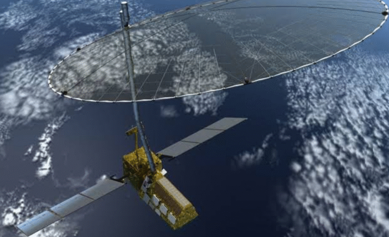
What Makes NISAR Unique: Dual-Band Radar Imaging System
At the heart of the NISAR satellite lies its cutting-edge technology: a dual-frequency Synthetic Aperture Radar system—one operating in the L-band (provided by NASA) and another in the S-band (developed by ISRO). This dual system allows the satellite to monitor a wide range of geophysical phenomena across the globe.
From monitoring soil moisture and forest biomass to tracking landslides, glacial melts, and sea-level rise, the satellite’s radar will capture time-sensitive and location-specific data at a frequency and accuracy that previous systems could only dream of.
Each orbit will produce near-real-time 3D mapping of Earth’s surface, making NISAR a game-changer for emergency response teams, climate scientists, agricultural planners, and geologists worldwide.
Launch Preparations at Sriharikota: The Final Countdown
According to ISRO chairman V Narayanan, both the satellite and the GSLV launch vehicle have already arrived at the Satish Dhawan Space Centre in Sriharikota. This coastal launch site in Andhra Pradesh is no stranger to high-profile launches, but NISAR adds a layer of international prestige and technical complexity.
In an exclusive update, Narayanan confirmed that a rigorous set of final reviews and system checks will begin this week. These involve verifying payload integration, trajectory programming, and ground support readiness. If all milestones are cleared on time, the satellite is expected to be mounted on the launch vehicle by mid-July.
Given the global significance and scale of this mission, Indian and American teams are working around the clock to ensure precision, safety, and mission success.
Earth’s Eyes from the Sky: Mission Objectives and Global Impact
So, what exactly will NISAR do once it’s in orbit?
Operating at an altitude of approximately 747 kilometers, the satellite will continuously map Earth’s entire land and ice masses every 12 days. It will observe over 90% of the globe, delivering high-resolution data on:
- Ice sheet collapses in the Arctic and Antarctica
- Coastal erosion and sea-level changes
- Earthquakes, landslides, and volcanic movements
- Tropical deforestation and illegal logging
- Agriculture, soil health, and drought forecasting
These observations will not only feed climate models but also help governments prepare better for disasters, manage urban growth, and protect fragile ecosystems.
For countries vulnerable to climate change including many in the Middle East and South Asia the satellite’s insights could be nothing short of life-saving.
Science Meets Diplomacy: The Power of Indo-US Collaboration
While the tech specs of NISAR are impressive, the mission also represents something much larger the rising strength of India-US bilateral relations. It embodies the shared commitment of both democracies to pursue peaceful space exploration and climate stewardship.
Over the past few years, both nations have made significant strides in space diplomacy. Initiatives like the Artemis Accords, critical partnerships in Moon missions, and now NISAR reflect a matured, multilayered alliance between NASA and ISRO.
This mission also underlines India’s emergence as a dependable technology partner for the West not just as a launch provider but as a co-developer of frontier technologies.
Implications for the Middle East and UAE
NISAR’s high-resolution mapping of arid regions, soil conditions, and land deformation has strong implications for countries in the Middle East. The UAE, which has already invested heavily in space with missions like the Emirates Mars Mission and MBZ-SAT, could benefit significantly from NISAR data for:
- Water resource planning
- Agricultural resilience in desert environments
- Coastal sustainability
- Real-time monitoring of seismic zones
As UAE continues its 2030 sustainability vision, tools like NISAR can offer crucial insights for policy and planning.
This also opens doors for future collaborations between NASA, ISRO, and space agencies in the Gulf Cooperation Council (GCC) states, especially with UAE emerging as a regional hub for aerospace innovation.
What’s Next After Launch: Timeline and Data Sharing
Once successfully launched, the satellite will undergo an initial phase of orbital validation, instrument calibration, and system diagnostics. Within three to six months of launch, NISAR will begin its primary scientific operations.
The mission is expected to last for at least three years, with real-time data feeds available to global research institutions, disaster response agencies, and government bodies. NASA and ISRO have already outlined open-data policies to ensure wide accessibility.
Moreover, new AI-powered platforms will assist in analyzing the radar data, allowing insights to be deployed swiftly in times of crisis like landslides, tsunamis, or droughts.
The Bigger Picture: A New Era in Earth Observation
With the impending launch of NISAR, the world stands on the brink of a revolution in Earth science. Gone are the days when researchers waited months for climate data. NISAR will provide dynamic, timely, and three-dimensional views of our ever-changing planet.
It is not just a satellite it is humanity’s mirror in the sky.
Whether it’s used for tracking carbon emissions, predicting the next earthquake, or building smarter cities, the data from NISAR will power decisions that affect billions of lives. And at the heart of it all is a partnership that bridges continents, ideologies, and aspirations.
Eyes Up, Earth First
As the July 2025 launch window nears, the countdown is more than a technical exercise it’s a countdown to clarity. In a world fraught with environmental, humanitarian, and economic challenges, NISAR arrives as a tool of truth.
NASA and ISRO have built a mission not only for scientific exploration but also for sustainable living on Earth. And as the rocket prepares to lift off from Sriharikota, all eyes quite fittingly will be on the skies.


1 Comment
[…] According to Dr. Narayanan, launches for different modules of the station are expected to begin by 2028, with full deployment targeted for completion by 2035. The construction will be gradual, adopting a modular architecture that enables each component to be launched separately and assembled in space using advanced docking systems, such as those tested during the SPADEX program. […]
Comments are closed.